NEWS AND EVENTS
2024


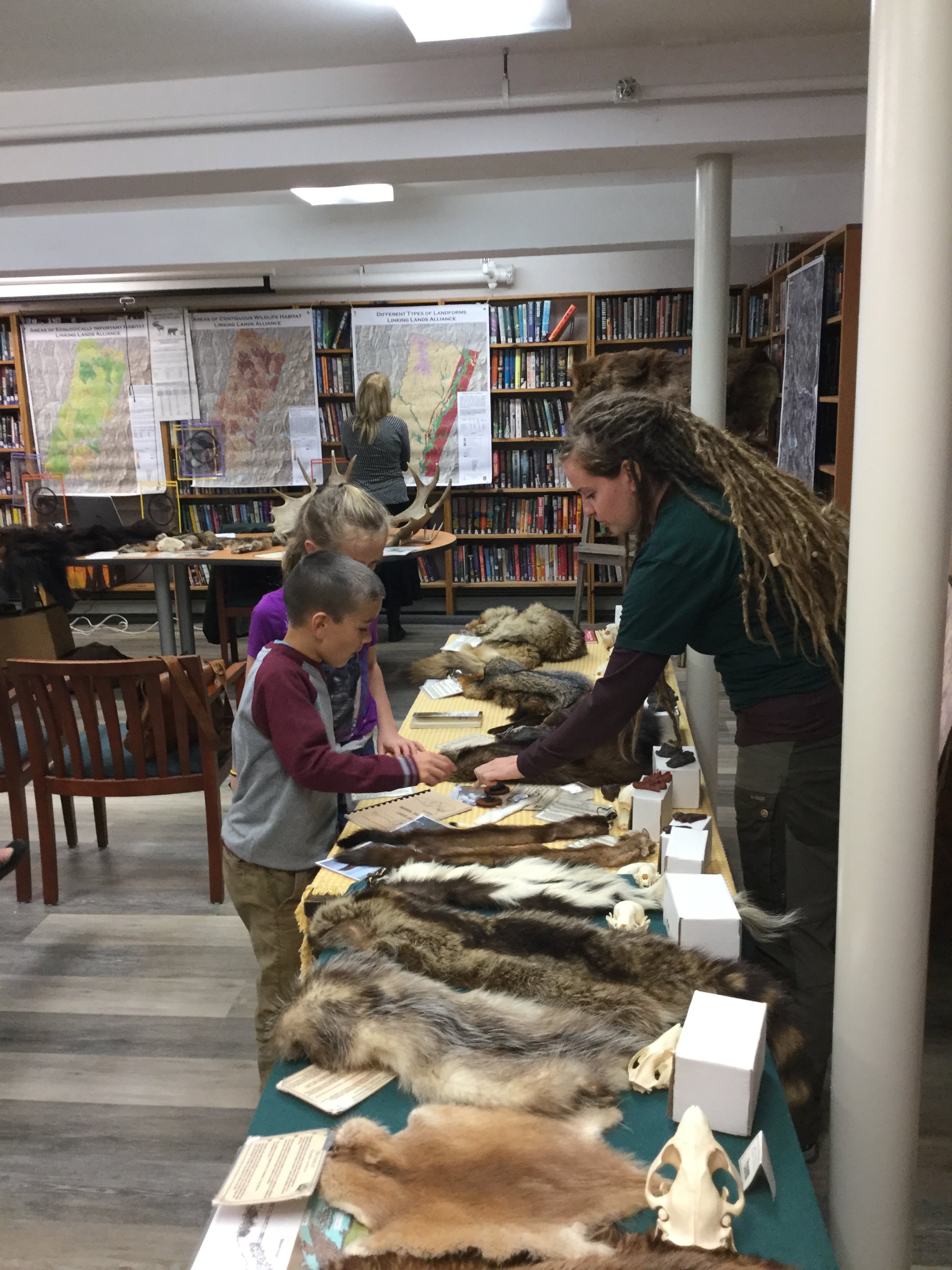
LLA Scientific Maps Go to School Project
We’re excited to announce in that August, we received our 8th year of support from the New Hampshire Charitable Foundation’s Wellborn Ecology Fund. This funding makes it possible for LLA to provide our maps and educational materials to additional schools this fall.
Additional project support comes from Staples and the Coop Food Stores’ Pennies for Change program.
We appreciate your continued support of our LLA Scientific Maps Go to School Project.
2023
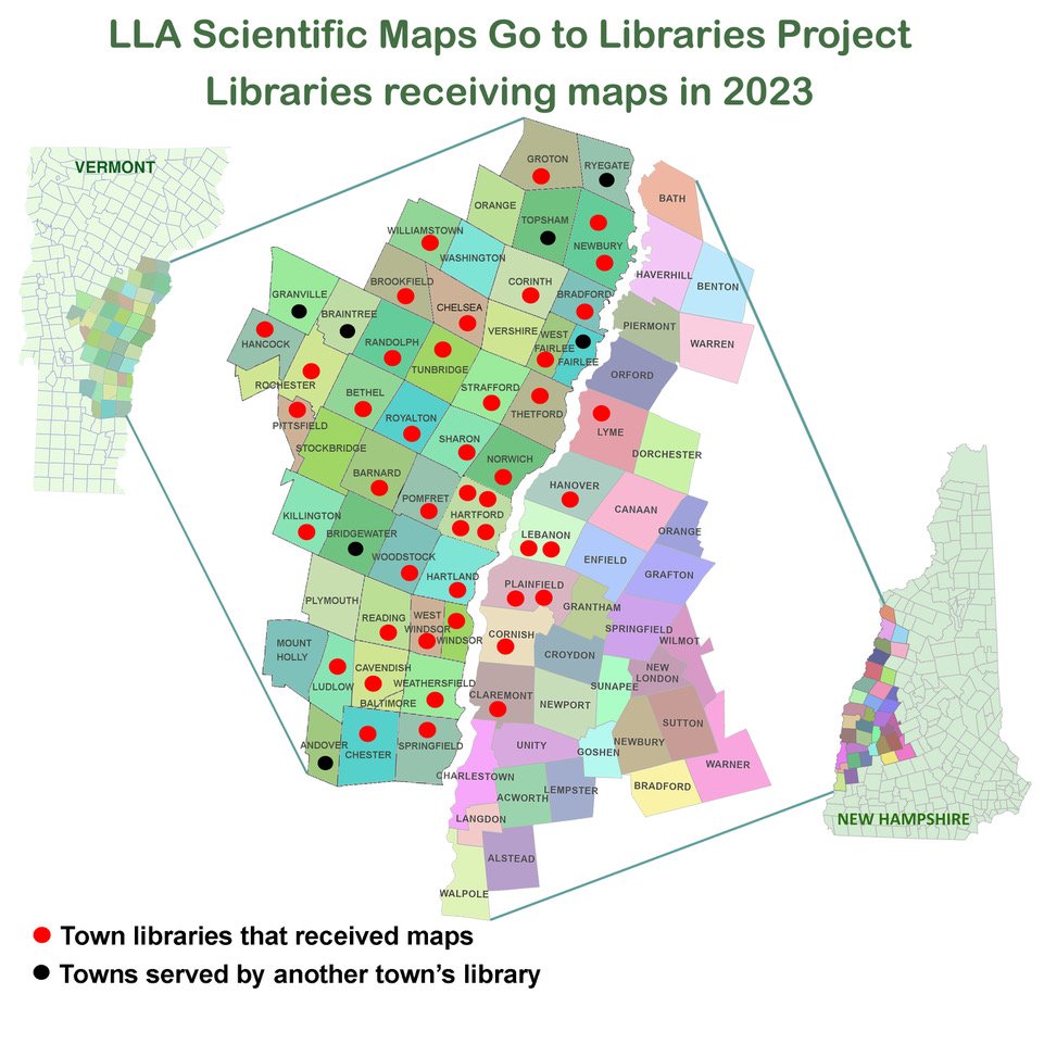
In September, LLA received a major donation from Mascoma Bank to fund our LLA Maps Go to Vermont and New Hampshire Libraries Project. We were able to provide 45 libraries with our Scientific place-based maps. Additional funding for this project comes from a generous donation from the Hanover Food Stores’ Pennies for Change program.
Thanks Mascoma Bank and Coop Food Stores for helping us get this project rolling. We hope to reach out to Libraries in the remaining towns once we secure more funding.


LLA Scientific Maps Go to School Project
In August, we were honored to be awarded our 7th year of support from the New Hampshire Charitable Foundation’s Wellborn Ecology Fund. This funding makes it possible for LLA to provide our maps and educational materials to another 14 schools this fall.
Additional support for the project comes from Staples and the Coop Food Stores’ Pennies for Change program.
We appreciate your continued support of our LLA Scientific Maps Go to School Project.

LLA begins a new project, providing free LLA Scientific Town and Regional Maps to our Local VT & NH Town Libraries. Librarian response has been overwhelming. We are currently fundraising so we can provide 170 maps to our Libraries.
LLA’s Facebook and Eco Calendar were only minimally accessed so we have decided to close both accounts and focus our energy on more productive projects.

LLA is selected as Coop Food Stores’ Pennies for Change October 2023 Community Partner.
2022

Thanks to the Upper Valley Food Coop for their Common Cents donation.
LLA Scientific Maps Go to School Project
LLA Scientific Maps Go to School year 6, supported by a generous grant from the New Hampshire Charitable Foundation’s Wellborn Ecology Fund and Map printing discounts at Staples.

2021
New Hampshire’s new Town and Regional Maps completed.


Thank you to the Coop Food Stores’ Pennies for Change donation.
LLA Scientific Maps Go to School Project
LLA Scientific Maps Go to School year 5, supported by a grant from the New Hampshire Charitable Foundation’s Wellborn Ecology Fund and Map printing discounts at Staples.


Thank to the New Hampshire Charitable Foundation’s Wellborn Ecology Fund
2020
37 new Vermont Town maps and 3 expanded regional maps completed and uploaded to website. We can now partner with teachers in more VT towns.


Received a Coop Food Stores’ Pennies for Change donation.
LLA Scientific Maps Go to School Project
LLA Scientific Maps Go to School year 4, supported by a grant from the New Hampshire Charitable Foundation’s Wellborn Ecology Fund and Map printing discounts at Staples.

LLA expands into New Hampshire. Hires a GIS map maker at UVLSRPC to make 36 NH town maps and 3 regional NH maps, made possible by grants and donations from: Mascoma Bank Foundation, Coop Food Stores’ Pennies for Change; New Hampshire Charitable Foundation's Wellborn Ecology Fund.

2019
Received a grant from the Jack and Dorothy Byrne Foundation for Website Hosting for 7-8 years.


LLA provides maps and education materials to additional schools in each town. Funded by a donation from the Emily Landecker Foundation.


Received an Upper Valley Food Coop Common Cents donation.
Presented LLA's Maps to educators at Wellborn Ecology Funds' Upper Valley Teaching Place Collaborative.
Led Landowner Wildlife Habitat outdoor workshop that included the following experts: Audubon, Fish and Wildlife, Foresters, VT Coverts.


LLA has a display at ONRCD’s Annual Forestry Presentation about the 1938 Hurricane by Stephen Long


Co-hosted a Wildlife Management Presentation with a Quechee State Park Ranger showcasing LLA's Maps at the Quechee Library.
Quechee Library Wildlife Presentation


LLA Scientific Maps Go to School Project
LLA Scientific Maps Go to School year 3, supported by a grant from the New Hampshire Charitable Foundation’s Wellborn Ecology Fund and Map printing discounts at Staples.

2018
LLA's Website launched. High resolution Town and Regional maps and educational materials available to all.

LLA Scientific Maps Go to School Project
LLA Scientific Maps Go to School year 2, supported by a grant from the New Hampshire Charitable Foundation’s Wellborn Ecology Fund and Map printing discounts at Staples.

LLA expands area, works with a GIS mapper from TRORC to create 37 more Vermont town maps and 3 new regional maps. Funded by grants from the Mascoma Bank Foundation and by a grant from the New Hampshire Charitable Foundation’s Wellborn Ecology Fund.

Set up Facebook page with regional maps (low resolution) and educational materials.
LLA has display at VINS Black Bear Presentation by Forrest Hammond

LLA has a display at ONRCD’s Annual Forestry Presentation by Ben Kilham


2017
LLA Scientific Maps Go to School Project
LLA Scientific Maps Go to School Project. Developed NGSS activities to use with LLA’s maps, provided teachers with LLA's Town and Regional maps and an orientation to LLA maps and educational materials. Supported by a grant from the New Hampshire Charitable Foundation’s Wellborn Ecology Fund and Map printing discounts at Staples.


Received a Mascoma Bank Foundation Grant to develop a webpage. LLA's maps and educational materials will be available to teachers, students, and landowners.
Ottauquechee Natural Resources Conservation District (ONRCD) becomes LLA’s Fiscal Sponsor
2016
Presented Town and Regional maps to Hartland Conservation Commission
2015
Organized 3rd neighborhood Forest Bird Habitat Assessment, Hartford Jericho Area (17 parcels, 623 acres).
Hosted an LLA Neighborhood groups Bird Walk.
10 Vermont Town maps for Bobcat activity completed.


2014
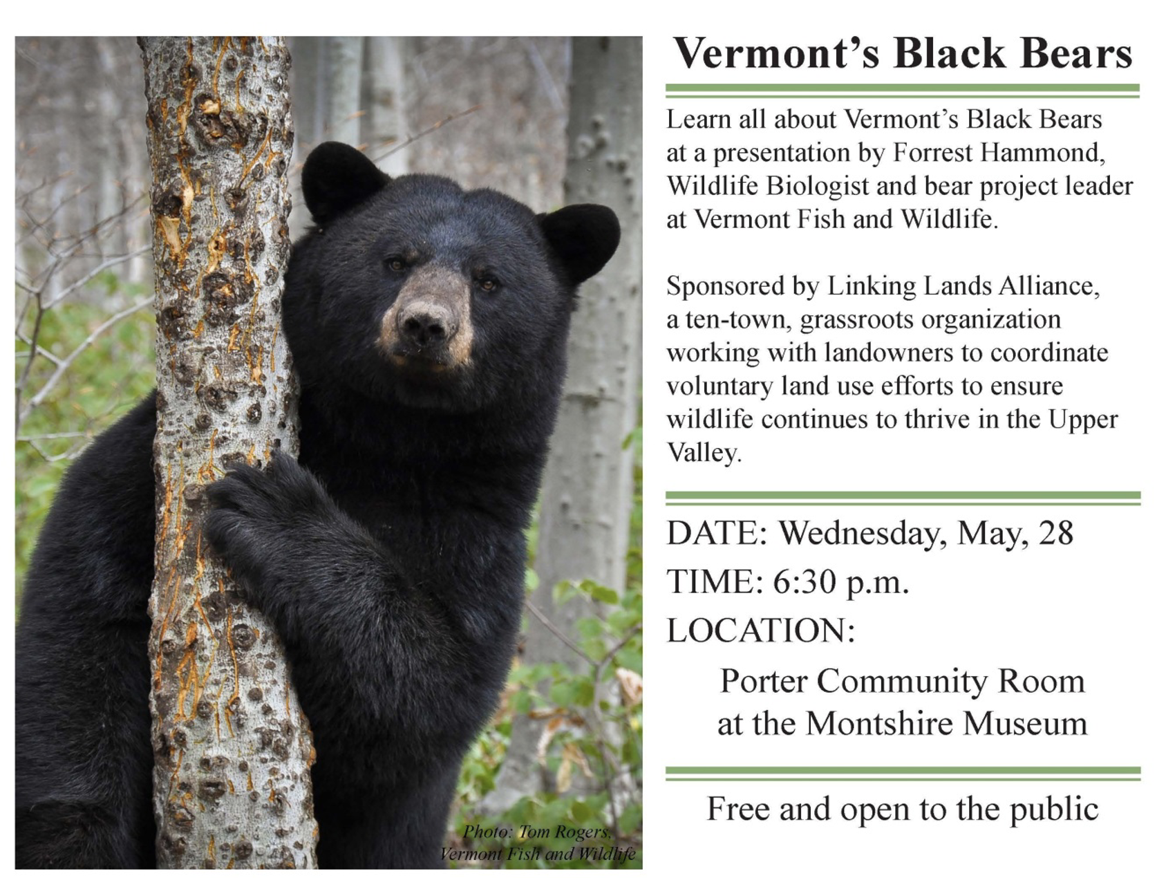
LLA hosts Forrest Hammond, bear biologist, at Montshire Museum with LLA maps.

Organized 2nd neighborhood Forest Bird Assessment, Hartford Dothan Ridge (10 parcels, 788 acres).


Worked with GIS mapper at TRORC on 10 Vermont place-based maps for educational Bobcat unit.
2013
Presented LLA maps to Beaver Meadow and Bugbee Senior Center.
Organized a neighborhood Forest Bird Assessment, Strafford Alger Brook (9 parcels, 850 acres).
2012
Coordinated with VINS to update their educational Bobcat activity to use town place-based maps.
Presented LLA map to Sharon Conservation Commission.
2011
Where Wildlife Roam, a year-long public outreach campaign with 4 wildlife talks: Bear; Moose; Fisher; and Forest Birds to showcase LLA’s New 10-Town Regional map. Funded by New Hampshire Charitable Foundation's Wellborn Ecology Fund.


2010
Hosted an Earth Day Event at Vermont Institute of Natural Science (VINS) with bobcat talk to introduce LLA’s new map.


First regional map with prioritized wildlife habitat blocks completed.


2009

LLA partners with Community Wildlife Program of the Vermont Department of Fish and Wildlife to help with mapping.
2007-2008
MTCN becomes Linking Lands Alliance (LLA) and expands to include 10 VT Upper Valley Towns: Hartland; Woodstock; Hartford; Pomfret; Norwich; Sharon; Thetford; Strafford; W. Fairlee; Vershire.

2005-2006
Formed Multi-town Conservation Network (MTCN) to focus mapping efforts on Hartford, Norwich, Thetford, and Hartland.
2003-2004
Formed Upper Valley Conservation Network to work on mapping wildlife habitat in VT and NH. It was too challenging to coordinate mapping in two states.
2001-2002
Keeping Track Training to study wildlife in four towns, Hartford, Norwich, Thetford and Vershire, Funded by a grant from the New Hampshire Charitable Foundation’s Wellborn Ecology Fund.
2000
LLA had its humble beginnings in the Pharmacology break room at Dartmouth Medical School where 2 coworkers would talk about wildlife in their towns of Hartford VT and Thetford VT and wonder how large mammals crossed the landscape. We were both on our Towns’ Conservation Commissions and frustrated because Town plans, Forestry plans and Recreation plans all had language about protecting wildlife habitat, but there were no maps of wildlife habitat. Hartford and Thetford don’t abut, fortunately just down the hall in the Biology Department was someone on the Norwich VT Conservation Commission and he was also interested in wildlife habitat and connectivity. We now had 3 abutting towns - Hartford, Norwich, and Thetford… the rest is history.